The northwestern part of Greece is pictured in this image acquired on 28 April by the Landsat-8 satellite. The Ionian Sea dominates the left side of the image, with the Ambracian Gulf near the center. In the upper-left corner we can see the Paxi islands. Paxos, to the north, boasts beautiful beaches mainly along its eastern coast, with dramatic cliffs and caves dominating the west side. The smaller island to the south, Antipaxos, is also known for its beaches as well as its traditional vineyards.
This image is featured on the Earth from Space video program.
Photo credit: USGS
The swirling eye of Typhoon Soulik as it approached Taiwan last Friday is caught by a tiny espresso cup-sized camera on one of ESA’s smallest satellites, Proba-2. This X-Cam image of Typhoon Soulik was acquired on 12 July at 10:14 GMT. Less than a cubic meter in size, Proba-2 focuses on observing solar activity and space weather. But it also keeps a small eye on its homeworld. Among the 17 experimental technologies hosted on Proba-2 is the compact Exploration Camera, X-Cam. Housed on the underside of the satellite, the monochrome X-Cam observes in the visible and infrared with a 100° field of view.
Photo credit: ESA
This Envisat radar image is centered on the man-made Raystown Lake in the US state of Pennsylvania. Near the top of the lake – which appears as a snaking red and blue line – there is a bright white radar reflection from the Raystown Dam. The area pictured is part of the greater Valley and Ridge Appalachians, in the Appalachian Mountain range. The lines that cut through the image are the long, even ridges characteristic of this region. One of the significant ridges is Tuscoarora Mountain in the lower-right corner. This is a compilation of three radar images from 23 December 2007, 2 March 2008 and 11 May 2008.
This image is featured on the Earth from Space video program.
Image credit: ESA
The town of Kirkenes in northernmost Norway, with its 3400 inhabitants, is preparing for an expected boom as a shipping hub, as global warming has led to the opening up of the Northern Sea Route along Russia's Arctic coastline. The travel time between Tokyo and Hamburg, for example, has been cut 40%. Ten to fifteen percent of Chinese international trade could take this route by 2020, according to the director of the Chinese Polar Research Institute. The image was acquired May 19, 2003, covers an area of 24 x 25.5 km, and is located at 69.7 degrees north latitude, 30 degrees east longitude.
Image credit: NASA/GSFC/METI/ERSDAC/JAROS, and U.S./Japan ASTER Science Team
Heavy rains, which began in mid-June, have resulted in major flooding along the Parana River in Argentina. Thousands of people have been forced to evacuate their homes in cities along the river. The neighboring countries of Paraguay, Uruguay and Brazil have also been affected. Vegetated areas are shown in shades of red; the river and flooded areas are blue and turquoise; clouds are white and light blue. This image from the Advanced Spaceborne Thermal Emission and Reflection Radiometer (ASTER) instrument, acquired on July 6, 2013, covers an area of 54 by 28.5 kilometers (33.5 by 17.7 miles), and is located at 28.2 degrees south latitude, 59.1 degrees west longitude.
Image credit: NASA/GSFC/METI/ERSDAC/JAROS, and U.S./Japan ASTER Science Team
The foothills of the Andes mountains near the southern coast of Peru were captured by the Kompsat-2 satellite on 4 May 2011. The Andes stretch about 7000 km from Venezuela down South America’s west coast to the top of Argentina. The mountain range is the result of the Nazca and Antarctic tectonic plates moving under the South American plate – a geological process called ‘subduction’. This process is also responsible for the Andes range’s volcanic activity.
Photo credit: KARI/ESA

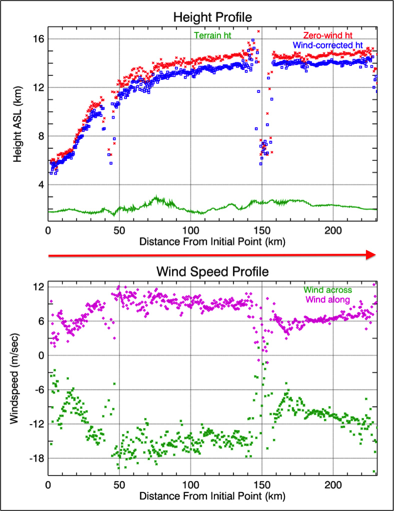
Lightning ignited the Silver Fire in western New Mexico on June 7, 2013. It has since consumed more than 137,000 acres of timber in a rugged area of the Gila National Forest that has not seen large fires for nearly a century. On the morning of June 28, as the fire exploded in intensity, NASA's Terra spacecraft passed over the fire, allowing the NASA Jet Propulsion Laboratory-built Multi-angle Imaging SpectroRadiometer (MISR) instrument on Terra to capture this image of extensive smoke. Two large pulses of fire generated pyro-cumulonimbus clouds. Brownish smoke, visible to the northwest of the active fire area, has entered the lower stratosphere. An active pulse of fire at the eastern end of this smoke is seen to be forming a new pyro-cumulonimbus tower that rises to a height of more than 8.7 miles (14 kilometers).
MISR views every scene it passes over from nine different angles. This unique design allows it to measure cloud and aerosol heights and the speed that smoke is moving due to horizontal wind using stereoscopic techniques. The plots in Figure 1 show the height of Silver Fire smoke along a line marked by the red arrow in the image. The profile crosses both smoke clouds, which rise to almost 9.3 miles (15 kilometers) in altitude above sea level (ASL). The lower plot shows the wind speeds retrieved by MISR in the direction across the image swath and in the direction along the satellite track.
These data were acquired during Terra orbit 71959.
Photo credit: NASA/GSFC/LaRC/JPL, MISR Team


