Saturday, August 31, 2013

Anatolia's Lakes Tersakan and Tuz


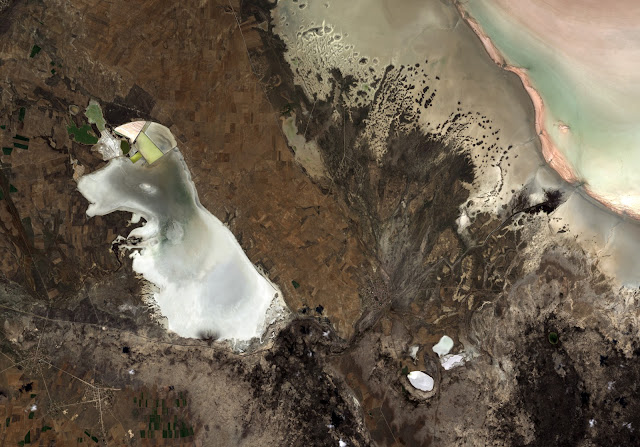
This ALOS image was acquired over Anatolia’s dry, central plateau in Turkey. On the left side we can see the whole of Lake Tersakan, with part of Lake Tuz in the upper right corner.

Lake Tuz is Turkey’s second largest lake, as well as one of the largest saline lakes in the world. During the summer months, however, the lake water recedes to expose a thick layer of salt.

The bright white surface during these dry summer months has been used by Earth-observing satellites to calibrate their sensors for the color white – much like how you would adjust a camera’s white balance setting.

Japan’s Advanced Land Observing Satellite (ALOS) captured this image on 21 October 2010 with its Advanced Visible and Near Infrared Radiometer type-2 instrument.

This image is featured on the Earth from Space video program.

Photo credit: JAXA, ESA
Friday, August 30, 2013

Greenland's Hidden Grand Canyon


Hidden for all of human history, a 460 mile long canyon has been discovered below Greenland's ice sheet. Using radar data from NASA's Operation IceBridge and other airborne campaigns, scientists led by a team from the University of Bristol found the canyon runs from near the center of the island northward to the fjord of the Petermann Glacier.

A large portion of the data was collected by IceBridge from 2009 through 2012. One of the mission's scientific instruments, the Multichannel Coherent Radar Depth Sounder, operated by the Center for the Remote Sensing of Ice Sheets at the University of Kansas, can see through vast layers of ice to measure its thickness and the shape of bedrock below.

Video credit: NASA

Note: For more information, see Mega-Canyon Discovered Beneath Greenland Ice.

Wednesday, August 28, 2013

The Spread of Western Wildfire Pollution


A new movie produced with data from the Atmospheric Infrared Sounder (AIRS) instrument on NASA's Aqua spacecraft shows the spread of carbon monoxide pollution across North America from fires in the Western U.S., including the Beaver Creek Fire in Idaho and the Rim Fire in California. The movie shows carbon monoxide concentrations at altitude 18,000 feet (5.5 kilometers) as measured by AIRS.

About AIRS
The Atmospheric Infrared Sounder, AIRS, in conjunction with the Advanced Microwave Sounding Unit, AMSU, senses emitted infrared and microwave radiation from Earth to provide a three-dimensional look at Earth's weather and climate. Working in tandem, the two instruments make simultaneous observations all the way down to Earth's surface, even in the presence of heavy clouds. With more than 2,000 channels sensing different regions of the atmosphere, the system creates a global, three-dimensional map of atmospheric temperature and humidity, cloud amounts and heights, greenhouse gas concentrations, and many other atmospheric phenomena. Launched into Earth orbit in 2002, the AIRS and AMSU instruments fly onboard NASA's Aqua spacecraft and are managed by NASA's Jet Propulsion Laboratory in Pasadena, Calif., under contract to NASA. JPL is a division of the California Institute of Technology in Pasadena.

Video credit: NASA/JPL-Caltech

Saturday, August 24, 2013

CERN and Geneva, Switzerland


The CERN Large Hadron Collider is the world's largest and highest-energy particle accelerator. Built from 1998 to 2008, this year it was the site of the confirmation of the existence of the Higgs Boson, proposed by Peter Higgs in 1964. The accelerator lies in a tunnel 27 km in circumference (shown by the yellow circle), as deep as 175 m beneath the French-Swiss border northwest of Geneva. The image was acquired July 26, 2012, covers an area of 14.2 x 15.4 km, and is located at 46.3 degrees north latitude, 6.2 degrees east longitude.

Photo credit: NASA/GSFC/METI/ERSDAC/JAROS, and U.S./Japan ASTER Science Team

Tuesday, August 20, 2013

Changes in Australia's Mass, June 2010 to February 2011


Changes in Australia's mass as reported by data from NASA's Gravity Recovery and Climate Experiment (GRACE) satellites from June 2010 to February 2011. Areas in greens and blues depict the greatest increases in mass, caused by excessive precipitation. The contour lines represent various land surface elevations. A new study co-authored and co-funded by NASA finds extensive flooding in Australia, combined with the continent's soils and unique topography, were the biggest contributors to the drop in global sea level observed in 2010 and 2011.

Image credit: NCAR/NASA/JPL-Caltech

Note: For more information, see Littlest Continent Had Biggest Role in Sea Level Drop.

Saturday, August 17, 2013

Star Dunes in the Algerian Sahara


Radially symmetrical, star dunes are pyramidal sand mounds with slipfaces on three or more arms that radiate from the high center of the mound. They tend to accumulate in areas with multidirectional wind regimes. Star dunes grow upward rather than laterally. They dominate the Grand Erg Oriental of the Algerian Sahara, as depicted in this image acquired October 27, 2012. It covers an area of 37 x 43 km, and is located at 29.8 degrees north latitude, 7.9 degrees east longitude.

Photo credit: NASA/GSFC/METI/ERSDAC/JAROS, and U.S./Japan ASTER Science Team