Showing posts with label MISR. Show all posts

Monday, January 20, 2014

Colby Fire Anaglyph


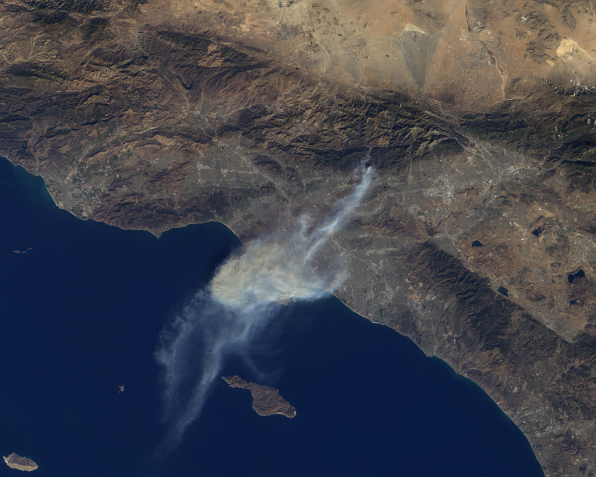
On January 16, 2014, dry conditions and warm winter temperatures in California permitted embers from a campfire in the hills above Glendora, California, to grow into a large wildfire that claimed several homes, caused mandatory evacuations of about 2,000 people, and sent smoke and ash across the Los Angeles Basin, prompting an air quality alert by public health officials. The Multi-angle Imaging SpectroRadiometer (MISR) instrument aboard NASA's Terra spacecraft passed over the region at 10:45 a.m. on January 16, about five hours after the fire was first reported.

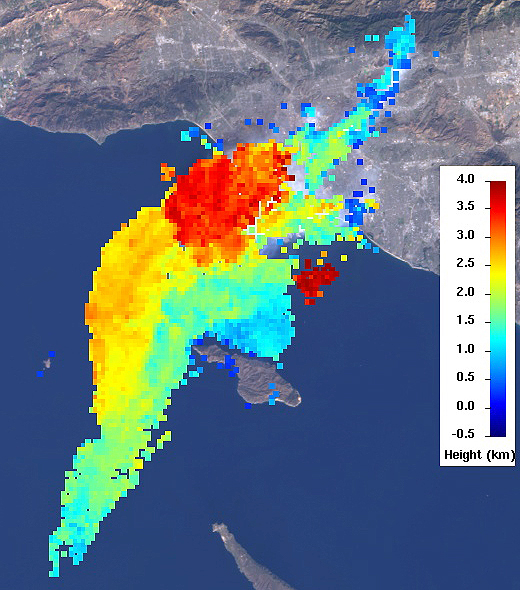
This set of images of the Colby Fire shows a natural color rendering (Figure 1) from MISR's vertical-viewing (nadir) camera. Winds carried the smoke out over the Pacific Ocean to at least 118 miles (190 kilometers) from the inland fire location. Combining the MISR nadir image with a view acquired at 46 degrees off of nadir, a stereoscopic "anaglyph" image is generated, giving a 3-D view of the plume when viewed with red/blue glasses (red filter over the left eye). To give the stereoscopic effect, this image is rotated so that North is at the left. A computer-processed height field is shown in Figure 2, indicating that smoke was elevated to a height of about 2.5 miles (4 kilometers), contributing to the widespread dispersal of the airborne particulates. The results of this analysis also place the areal coverage of the smoke and ash at about 3,860 square miles (10,000 square kilometers).

These data were collected on orbit 74901 of the Terra spacecraft (path 41, MISR blocks 63-64).

Image credit: NASA/GSFC/LaRC/JPL, MISR Team

Note: For more information, see PIA17923: NASA's Terra Spacecraft Images Destructive Colby Fire East of Los Angeles.

Friday, October 25, 2013

Wildfires in the Blue Mountains


A mild winter and an extremely hot September in Australia have led to an early start to the fire season Down Under. A number of significant bush fires continue to rage in the Blue Mountains to the west and north of Sydney, the most populous city in the country, with nearly 4.6 million people. The ongoing fires have led to the announcement of a state of emergency for the area, and days of high temperatures and strong winds have exacerbated the situation.

The Multi-angle Imaging SpectroRadiometer (MISR) instrument on NASA's Terra spacecraft passed over the region around 11:00 a.m. AEDT (00:00 UTC) on October 20, 2013. This stereo anaglyph is a composite of images from two of MISR's nine cameras; the nadir (0°) camera is shown in the blue/green channels and the Ba (45.6° aft) camera is shown in the red channel. The images have been rotated clockwise so that north is to the right and west is toward the top. The anaglyph can be viewed with standard red/blue 3D glasses with the red lens over the left eye.

Sydney itself is in the bottom center of the image, with much of its area covered by a thin cloud of smoke. The Blue Mountains rise about 0.6 miles (1 kilometer) above sea level, and analysis of the MISR data shows that the plume extending over the city is at an altitude of just over 1 mile (2 kilometers). On this date, the winds were relatively light and the temperature was around 77 degrees Fahrenheit (25 degrees Celsius). The fires to the north have plumes that are somewhat lower in altitude.

The image extends from about 32.35 degrees south to 34.8 degrees south and 149.1 degrees east to 151.8 degrees east, covering about 168 miles (270 kilometers) in the north-south direction and 158 miles (255 kilometers) in the east-west direction. The images are a portion of the data acquired during Terra orbit 73608 from blocks 116 to 118 within World Reference System-2 path 90.

Image credit: NASA/GSFC/LaRC/JPL, MISR Team

Thursday, July 4, 2013

Silver Fire, New Mexico


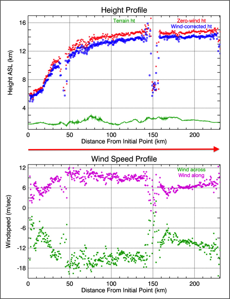
Lightning ignited the Silver Fire in western New Mexico on June 7, 2013. It has since consumed more than 137,000 acres of timber in a rugged area of the Gila National Forest that has not seen large fires for nearly a century. On the morning of June 28, as the fire exploded in intensity, NASA's Terra spacecraft passed over the fire, allowing the NASA Jet Propulsion Laboratory-built Multi-angle Imaging SpectroRadiometer (MISR) instrument on Terra to capture this image of extensive smoke. Two large pulses of fire generated pyro-cumulonimbus clouds. Brownish smoke, visible to the northwest of the active fire area, has entered the lower stratosphere. An active pulse of fire at the eastern end of this smoke is seen to be forming a new pyro-cumulonimbus tower that rises to a height of more than 8.7 miles (14 kilometers).

MISR views every scene it passes over from nine different angles. This unique design allows it to measure cloud and aerosol heights and the speed that smoke is moving due to horizontal wind using stereoscopic techniques. The plots in Figure 1 show the height of Silver Fire smoke along a line marked by the red arrow in the image. The profile crosses both smoke clouds, which rise to almost 9.3 miles (15 kilometers) in altitude above sea level (ASL). The lower plot shows the wind speeds retrieved by MISR in the direction across the image swath and in the direction along the satellite track.

These data were acquired during Terra orbit 71959.

Photo credit: NASA/GSFC/LaRC/JPL, MISR Team

Thursday, February 23, 2012

Earth's Clouds are Getting Lower


This image of clouds over the southern Indian Ocean was acquired on July 23, 2007 by one of the backward (northward)-viewing cameras of the Multi-angle Imaging SpectroRadiometer (MISR) instrument on NASA's polar-orbiting Terra spacecraft. The area covered by the image is 247.5 kilometers wide and 660 kilometers long, and is shown in an approximate perspective view at an angle of 60 degrees off of vertical. The solar zenith angle ranges from about 83 degrees at the top of the image to 88 degrees at the bottom, hence the lengthening of shadows cast by the clouds on the underlying ocean surface and reddening of the hues in the foreground. Stereoscopic analysis of the data from multiple MISR cameras indicates that the cloud tops visible here range in altitude from about 0.6 to 2.5 miles (1 to 4 kilometers). A new university study using MISR data revealed an overall trend of decreasing global cloud height during the last decade.

Photo credit: NASA/GSFC/METI/ERSDAC/JAROS, and U.S./Japan ASTER Science Team