Friday, October 25, 2013

Wildfires in the Blue Mountains


A mild winter and an extremely hot September in Australia have led to an early start to the fire season Down Under. A number of significant bush fires continue to rage in the Blue Mountains to the west and north of Sydney, the most populous city in the country, with nearly 4.6 million people. The ongoing fires have led to the announcement of a state of emergency for the area, and days of high temperatures and strong winds have exacerbated the situation.

The Multi-angle Imaging SpectroRadiometer (MISR) instrument on NASA's Terra spacecraft passed over the region around 11:00 a.m. AEDT (00:00 UTC) on October 20, 2013. This stereo anaglyph is a composite of images from two of MISR's nine cameras; the nadir (0°) camera is shown in the blue/green channels and the Ba (45.6° aft) camera is shown in the red channel. The images have been rotated clockwise so that north is to the right and west is toward the top. The anaglyph can be viewed with standard red/blue 3D glasses with the red lens over the left eye.

Sydney itself is in the bottom center of the image, with much of its area covered by a thin cloud of smoke. The Blue Mountains rise about 0.6 miles (1 kilometer) above sea level, and analysis of the MISR data shows that the plume extending over the city is at an altitude of just over 1 mile (2 kilometers). On this date, the winds were relatively light and the temperature was around 77 degrees Fahrenheit (25 degrees Celsius). The fires to the north have plumes that are somewhat lower in altitude.

The image extends from about 32.35 degrees south to 34.8 degrees south and 149.1 degrees east to 151.8 degrees east, covering about 168 miles (270 kilometers) in the north-south direction and 158 miles (255 kilometers) in the east-west direction. The images are a portion of the data acquired during Terra orbit 73608 from blocks 116 to 118 within World Reference System-2 path 90.

Image credit: NASA/GSFC/LaRC/JPL, MISR Team

Thursday, October 24, 2013

Uruk, Iraq


The ancient city of Uruk is located in present-day Iraq, on an abandoned channel of the Euphrates River. Uruk gave its name to the Uruk period, spanning circa 4000 to 3100 BCE. At its height around 2900 BCE, Uruk had more than 50,000 residents, making it the largest city in the world. The semi-mythical king Gilgamesh ruled Uruk in the 27th century BCE. The city was occupied until around 500 AD, and was re-discovered in 1849. On the image, Uruk is the round yellowish area in the upper right. The image was acquired July 18, 2007, covers an area of 14.4 x 15.9 km, and is located at 31.3 degrees north latitude, 45.6 degrees east longitude.

Photo credit: NASA/GSFC/METI/ERSDAC/JAROS, and U.S./Japan ASTER Science Team

Tuesday, October 22, 2013

Earth, by Juno


On October 9, NASA's Juno spacecraft flew past Earth, using our home planet's gravity to get the final boost it needed to reach Jupiter. The JunoCam instrument captured this monochrome view of Earth, and other instruments were tested to ensure they work as designed during a close planetary encounter.

The Juno spacecraft was launched from NASA's Kennedy Space Center in Florida on August 5, 2011. Juno's rocket, the Atlas 551, was only capable of giving Juno enough energy or speed to reach the asteroid belt, at which point the Sun's gravity pulled Juno back toward the inner solar system. The Earth flyby gravity assist put Juno on course for arrival at Jupiter on July 4, 2016.

Photo credit: NASA/JPL-Caltech/Malin Space Science Systems

Note: For more information, see PIA17516: Juno's Earth Flyby (Artist's Rendering).

Saturday, October 19, 2013

Amazon River


This Kompsat-2 image, acquired on 6 July 2012, shows the Amazon River in the heart of northern Brazil’s rainforest. The false color makes land vegetation appear pink, while water appears green and dark blue. In the upper-right corner, we can see some sparse clouds. The shades of pink vary – the bolder color representing thick vegetation with lighter pink showing where trees were possibly cut down. In fact, in the upper-left portion of the image, there’s a clear line between the two shades, showing where vegetation was cut. The white dots show man-made structures. With their unique view from space, Earth observation satellites have been instrumental in highlighting the vulnerability of the rainforests by documenting the scale of deforestation.

This image is featured on the Earth from Space video program.

Image credit: KARI/ESA

Friday, October 18, 2013

Canyonlands National Park, Utah


The desert southwest US is a showcase of geology. Canyonlands National Park in SE Utah is one such example. In this image, the Colorado River in the upper left corner forms the border of an area of outcrops of Permian (~280 million years old) Cedar Mesa Sandstone. Nearest the river, a series of arcuate faults has created a landscape of extremely narrow valleys. Further east a tributary of the Colorado has eroded the landscape into intricate feather-like drainage patterns. The image was acquired September 24, 2005, covers an area of 27 x 24 km, and is located near 38.1 degrees north latitude, 109.8 degrees west longitude.

Image credit: NASA/GSFC/METI/ERSDAC/JAROS, and U.S./Japan ASTER Science Team

Saturday, October 12, 2013

Arcachon Bay and the Dune of Pyla, France


The Arcachon Bay in France’s southwest Aquitaine region is pictured in this image acquired on on 8 September 2009 by Japan’s ALOS observation satellite. At the center of the image, we can see the large Dune of Pyla as an elongated light-brown rectangle. This large, sandy dune is about 2.7 km long, 500 m wide and about 110 m tall. In the upper right portion of the image is Arcachon Bay, home to oyster beds and farms.

ALOS was supported as a Third Party Mission, which means that ESA used its multi-mission ground systems to acquire, process, distribute and archive data from the satellite to its user community. In April 2011 the satellite abruptly lost power while mapping Japan’s tsunami-hit coastline.

This image is featured on the Earth from Space video program.

Photo credit: JAXA, ESA

Saturday, October 5, 2013

Southern Greenland


Clouds blur our view of the snow below in parts of this image acquired over the southern tip of Greenland by the Landsat-8 satellite on 30 May 2013. Long fjords reach far inland and, zooming in on the tips of some of their 'fingers', we can see ice streams that drain the Greenland ice sheet. In the lower part of the image, white dots speckle the North Atlantic Ocean, like stars in the night sky. These are icebergs that – although they appear insignificant in this image – pose a major threat to ships.

This image is featured on the Earth from Space video program.

Photo credit: USGS/ESA

Saturday, September 28, 2013

Athens, Greece


This image was taken on 4 January 2013 over central Athens, the capital and largest city of Greece. Near the center of the image is the famous Acropolis of Athens – standing high about the surrounding city as evident by the shadow to the north. Nearby to the southeast is the Temple of Zeus, with shadows from the remaining standing columns stretching across the grass. Further northeast are the National Gardens surrounding the Zappeion building. At the upper left corner of the gardens is the Greek parliament building overlooking Syntagma Square. In the lower-right corner we can see the large, white marble Panathenaic Stadium.

This image is featured on the Earth from Space video program.

Photo credit: European Space Imaging/DigitalGlobe

Friday, September 27, 2013

Kathmandu, Nepal


Kathmandu is the capital of Nepal, with a population of about 2.5 million inhabitants for the greater metropolitan area. The city is the gateway to tourism in Nepal, and is the center of the country's economy, with a literacy rate of 98%. The Kathmandu Valley is listed as a UNESCO World Heritage Site to recognize the rich number of monuments found in seven different monument zones. The image was acquired March 4, 2009, covers an area of 22 by 22 km, and is located at 27.6 degrees north latitude, 85.3 degrees east longitude.

Photo credit: NASA/GSFC/METI/ERSDAC/JAROS, and U.S./Japan ASTER Science Team

Thursday, September 26, 2013

Pakistan Epicenter


On September 24 at 11:29 GMT, a magnitude 7.7 earthquake struck in south-central Pakistan at a relatively shallow depth of 20 kilometers. The earthquake occurred as the result of oblique strike-slip motion, consistent with rupture within the Eurasian tectonic plate. Tremors were felt as far away as New Delhi as well as Karachi in Pakistan. Even though the immediate area to the epicenter is sparsely populated, the majority of houses are of mud brick construction and damage is expected to be extensive. The perspective view, looking to the east, shows the location of the epicenter in Pakistan's Makran fold belt. The image is centered near 27 degrees north latitude, 65.5 degrees east longitude, and was acquired December 13, 2012.

Photo credit: NASA/GSFC/METI/ERSDAC/JAROS, and U.S./Japan ASTER Science Team

Wednesday, September 25, 2013

Argentine Wildfires


Wildfires have struck the Cordoba province of northern Argentina, caused by high temperatures and strong winds. The large fire, which began on September 9, 2013, spread to more than 37,000 acres (15,000 hectares), destroyed numerous homes, and led to the evacuation of several villages. This image, acquired on September 22, 2013 by the Advanced Spaceborne Thermal Emission and Reflection Radiometer (ASTER) instrument on NASA's Terra spacecraft, shows the extent of the burned area in black. Healthy vegetation, like forests and farm land, is depicted in red. The image covers an area of 19 by 30 miles (30 by 49 kilometers), and is located near 32.1 degrees south latitude, 64.8 degrees west longitude.

Image credit: NASA/GSFC/METI/ERSDAC/JAROS, and U.S./Japan ASTER Science Team

Saturday, September 21, 2013

Libya's Al-Jawf Oasis


Deep in the Sahara Desert, the Al Jawf oasis in southeastern Libya is pictured in this image from Japan’s ALOS satellite. The city can be seen in in the upper left corner, while large, irrigated agricultural plots appear like Braille across the image. Between the city and the plots we can see the two parallel runways of the Kufra Airport. The agricultural plots reach up to a kilometer in diameter. Their circular shapes were created by a central-pivot irrigation system, where a long water pipe rotates around a well at the center of each plot. Since the area receives virtually no rainfall, fossil water is pumped from deep underground for irrigation.

Japan’s Advanced Land Observing Satellite (ALOS) captured this image on 24 January 2011 with its Advanced Visible and Near Infrared Radiometer type-2, which charts land cover and vegetation in the visible and near-infrared spectral bands at a resolution of 10 m. ESA supports ALOS as a Third Party Mission, which means ESA uses its multi-mission ground systems to acquire, process, distribute and archive data from the satellite to its user community.

This image is featured on the Earth from Space video program.

Photo credit: JAXA, ESA

Saturday, September 14, 2013

Red Tide Off the UAE


The coast of the United Arab Emirates hosts some of the largest desalination plants in the world. While the water they release may affect the coastal ecosystem, harmful and non-harmful algae blooms can also greatly affect the desalination plants. In particular, the local phenomenon known as the ‘red tide’ has affected desalination plants over the last four years, causing severe damage and sometimes bringing operations to a halt.

Satellite data can be used to identify and monitor red tide events – such as this one spreading from the Gulf of Oman into the Persian Gulf. This image was acquired by Envisat’s MERIS instrument on 22 November 2008.

Image credit: C-wams project, Planetek Hellas/ESA

Friday, September 13, 2013

Fernandina Volcano


ESA's Envisat satellite shows ground deformation around a volcano on Fernandina island in the GalĂ¡pagos islands, following the eruption in April 2009. The caldera is outlined in white, and the lava flow produced by the eruption is also in white, stretching to the coast.

Interferometric Synthetic Aperture Radar – or InSAR – is a technique where two or more satellite radar images over the same scene are combined to detect slight changes between them. Tiny changes on the ground cause changes in the radar signal and lead to rainbow-colored patterns in the combined image.

Image credit: ESA/M. Bagnardi, University of Miami

Thursday, September 12, 2013

Kuwait Oil Fields


In the desert of southern Kuwait, three oil fields spread out across the empty landscape. The country has the world's fifth largest oil reserves, and the 2.8 million people live in the eleventh richest country in the world. The massive oil reserves were discovered in the 1930s, after the country had emerged as an independent sheikhdom under the protection of the British Empire. The image was acquired September 27, 2009, covers an area of 30 x 54 km, and is located at 28.8 degrees north latitude, 47.8 degrees east longitude.

Photo credit: NASA/GSFC/METI/ERSDAC/JAROS, and U.S./Japan ASTER Science Team

Saturday, September 7, 2013

Uluru/Ayer's Rock


Uluru/Ayers Rock in the Australian outback is featured in this image from the Kompsat-2 satellite. The rock formation is anInselberg– German for ‘island mountain’ – a prominent geological structure that rises from the surrounding plain.

Hundreds of millions of years ago, this part of Australia was a shallow sea. Layers of sandstone settled on the ocean floor and were compressed. These hardened, horizontal layers were uplifted and tilted almost 90º upwards to their present position. The rock eroded slower than the surrounding softer deposits until the monolith stood high above an otherwise flat surface. From this perpendicular angle of the satellite acquisition, we can see those layers that were once horizontal and now appear to cut across the top of the formation.

The Korea Aerospace Research Institute’s Kompsat-2 satellite acquired this image on 15 September 2011. ESA supports Kompsat as a Third Party Mission, meaning it uses its ground infrastructure and expertise to acquire, process and distribute data to users.

This image is featured on the Earth from Space video program.

Photo credit: KARI/ESA

Saturday, August 31, 2013

Anatolia's Lakes Tersakan and Tuz


This ALOS image was acquired over Anatolia’s dry, central plateau in Turkey. On the left side we can see the whole of Lake Tersakan, with part of Lake Tuz in the upper right corner.

Lake Tuz is Turkey’s second largest lake, as well as one of the largest saline lakes in the world. During the summer months, however, the lake water recedes to expose a thick layer of salt.

The bright white surface during these dry summer months has been used by Earth-observing satellites to calibrate their sensors for the color white – much like how you would adjust a camera’s white balance setting.

Japan’s Advanced Land Observing Satellite (ALOS) captured this image on 21 October 2010 with its Advanced Visible and Near Infrared Radiometer type-2 instrument.

This image is featured on the Earth from Space video program.

Photo credit: JAXA, ESA

Friday, August 30, 2013

Greenland's Hidden Grand Canyon


Hidden for all of human history, a 460 mile long canyon has been discovered below Greenland's ice sheet. Using radar data from NASA's Operation IceBridge and other airborne campaigns, scientists led by a team from the University of Bristol found the canyon runs from near the center of the island northward to the fjord of the Petermann Glacier.

A large portion of the data was collected by IceBridge from 2009 through 2012. One of the mission's scientific instruments, the Multichannel Coherent Radar Depth Sounder, operated by the Center for the Remote Sensing of Ice Sheets at the University of Kansas, can see through vast layers of ice to measure its thickness and the shape of bedrock below.

Video credit: NASA

Note: For more information, see Mega-Canyon Discovered Beneath Greenland Ice.

Wednesday, August 28, 2013

The Spread of Western Wildfire Pollution


A new movie produced with data from the Atmospheric Infrared Sounder (AIRS) instrument on NASA's Aqua spacecraft shows the spread of carbon monoxide pollution across North America from fires in the Western U.S., including the Beaver Creek Fire in Idaho and the Rim Fire in California. The movie shows carbon monoxide concentrations at altitude 18,000 feet (5.5 kilometers) as measured by AIRS.

About AIRS
The Atmospheric Infrared Sounder, AIRS, in conjunction with the Advanced Microwave Sounding Unit, AMSU, senses emitted infrared and microwave radiation from Earth to provide a three-dimensional look at Earth's weather and climate. Working in tandem, the two instruments make simultaneous observations all the way down to Earth's surface, even in the presence of heavy clouds. With more than 2,000 channels sensing different regions of the atmosphere, the system creates a global, three-dimensional map of atmospheric temperature and humidity, cloud amounts and heights, greenhouse gas concentrations, and many other atmospheric phenomena. Launched into Earth orbit in 2002, the AIRS and AMSU instruments fly onboard NASA's Aqua spacecraft and are managed by NASA's Jet Propulsion Laboratory in Pasadena, Calif., under contract to NASA. JPL is a division of the California Institute of Technology in Pasadena.

Video credit: NASA/JPL-Caltech

Saturday, August 24, 2013

CERN and Geneva, Switzerland


The CERN Large Hadron Collider is the world's largest and highest-energy particle accelerator. Built from 1998 to 2008, this year it was the site of the confirmation of the existence of the Higgs Boson, proposed by Peter Higgs in 1964. The accelerator lies in a tunnel 27 km in circumference (shown by the yellow circle), as deep as 175 m beneath the French-Swiss border northwest of Geneva. The image was acquired July 26, 2012, covers an area of 14.2 x 15.4 km, and is located at 46.3 degrees north latitude, 6.2 degrees east longitude.

Photo credit: NASA/GSFC/METI/ERSDAC/JAROS, and U.S./Japan ASTER Science Team

Tuesday, August 20, 2013

Changes in Australia's Mass, June 2010 to February 2011


Changes in Australia's mass as reported by data from NASA's Gravity Recovery and Climate Experiment (GRACE) satellites from June 2010 to February 2011. Areas in greens and blues depict the greatest increases in mass, caused by excessive precipitation. The contour lines represent various land surface elevations. A new study co-authored and co-funded by NASA finds extensive flooding in Australia, combined with the continent's soils and unique topography, were the biggest contributors to the drop in global sea level observed in 2010 and 2011.

Image credit: NCAR/NASA/JPL-Caltech

Note: For more information, see Littlest Continent Had Biggest Role in Sea Level Drop.

Saturday, August 17, 2013

Star Dunes in the Algerian Sahara


Radially symmetrical, star dunes are pyramidal sand mounds with slipfaces on three or more arms that radiate from the high center of the mound. They tend to accumulate in areas with multidirectional wind regimes. Star dunes grow upward rather than laterally. They dominate the Grand Erg Oriental of the Algerian Sahara, as depicted in this image acquired October 27, 2012. It covers an area of 37 x 43 km, and is located at 29.8 degrees north latitude, 7.9 degrees east longitude.

Photo credit: NASA/GSFC/METI/ERSDAC/JAROS, and U.S./Japan ASTER Science Team

Saturday, July 27, 2013

Northwestern Greece


The northwestern part of Greece is pictured in this image acquired on 28 April by the Landsat-8 satellite. The Ionian Sea dominates the left side of the image, with the Ambracian Gulf near the center. In the upper-left corner we can see the Paxi islands. Paxos, to the north, boasts beautiful beaches mainly along its eastern coast, with dramatic cliffs and caves dominating the west side. The smaller island to the south, Antipaxos, is also known for its beaches as well as its traditional vineyards.

This image is featured on the Earth from Space video program.

Photo credit: USGS

Thursday, July 18, 2013

Typhoon Soulik


The swirling eye of Typhoon Soulik as it approached Taiwan last Friday is caught by a tiny espresso cup-sized camera on one of ESA’s smallest satellites, Proba-2. This X-Cam image of Typhoon Soulik was acquired on 12 July at 10:14 GMT. Less than a cubic meter in size, Proba-2 focuses on observing solar activity and space weather. But it also keeps a small eye on its homeworld. Among the 17 experimental technologies hosted on Proba-2 is the compact Exploration Camera, X-Cam. Housed on the underside of the satellite, the monochrome X-Cam observes in the visible and infrared with a 100° field of view.

Photo credit: ESA

Saturday, July 13, 2013

Raystown Lake, Pennsylvania


This Envisat radar image is centered on the man-made Raystown Lake in the US state of Pennsylvania. Near the top of the lake – which appears as a snaking red and blue line – there is a bright white radar reflection from the Raystown Dam. The area pictured is part of the greater Valley and Ridge Appalachians, in the Appalachian Mountain range. The lines that cut through the image are the long, even ridges characteristic of this region. One of the significant ridges is Tuscoarora Mountain in the lower-right corner. This is a compilation of three radar images from 23 December 2007, 2 March 2008 and 11 May 2008.

This image is featured on the Earth from Space video program.

Image credit: ESA

Wednesday, July 10, 2013

Kirkenes, Norway


The town of Kirkenes in northernmost Norway, with its 3400 inhabitants, is preparing for an expected boom as a shipping hub, as global warming has led to the opening up of the Northern Sea Route along Russia's Arctic coastline. The travel time between Tokyo and Hamburg, for example, has been cut 40%. Ten to fifteen percent of Chinese international trade could take this route by 2020, according to the director of the Chinese Polar Research Institute. The image was acquired May 19, 2003, covers an area of 24 x 25.5 km, and is located at 69.7 degrees north latitude, 30 degrees east longitude.

Image credit: NASA/GSFC/METI/ERSDAC/JAROS, and U.S./Japan ASTER Science Team

Tuesday, July 9, 2013

Flooding Along the Parana River


Heavy rains, which began in mid-June, have resulted in major flooding along the Parana River in Argentina. Thousands of people have been forced to evacuate their homes in cities along the river. The neighboring countries of Paraguay, Uruguay and Brazil have also been affected. Vegetated areas are shown in shades of red; the river and flooded areas are blue and turquoise; clouds are white and light blue. This image from the Advanced Spaceborne Thermal Emission and Reflection Radiometer (ASTER) instrument, acquired on July 6, 2013, covers an area of 54 by 28.5 kilometers (33.5 by 17.7 miles), and is located at 28.2 degrees south latitude, 59.1 degrees west longitude.

Image credit: NASA/GSFC/METI/ERSDAC/JAROS, and U.S./Japan ASTER Science Team

Friday, July 5, 2013

Peruvian Foothills


The foothills of the Andes mountains near the southern coast of Peru were captured by the Kompsat-2 satellite on 4 May 2011. The Andes stretch about 7000 km from Venezuela down South America’s west coast to the top of Argentina. The mountain range is the result of the Nazca and Antarctic tectonic plates moving under the South American plate – a geological process called ‘subduction’. This process is also responsible for the Andes range’s volcanic activity.

Photo credit: KARI/ESA

Thursday, July 4, 2013

Silver Fire, New Mexico


Lightning ignited the Silver Fire in western New Mexico on June 7, 2013. It has since consumed more than 137,000 acres of timber in a rugged area of the Gila National Forest that has not seen large fires for nearly a century. On the morning of June 28, as the fire exploded in intensity, NASA's Terra spacecraft passed over the fire, allowing the NASA Jet Propulsion Laboratory-built Multi-angle Imaging SpectroRadiometer (MISR) instrument on Terra to capture this image of extensive smoke. Two large pulses of fire generated pyro-cumulonimbus clouds. Brownish smoke, visible to the northwest of the active fire area, has entered the lower stratosphere. An active pulse of fire at the eastern end of this smoke is seen to be forming a new pyro-cumulonimbus tower that rises to a height of more than 8.7 miles (14 kilometers).

MISR views every scene it passes over from nine different angles. This unique design allows it to measure cloud and aerosol heights and the speed that smoke is moving due to horizontal wind using stereoscopic techniques. The plots in Figure 1 show the height of Silver Fire smoke along a line marked by the red arrow in the image. The profile crosses both smoke clouds, which rise to almost 9.3 miles (15 kilometers) in altitude above sea level (ASL). The lower plot shows the wind speeds retrieved by MISR in the direction across the image swath and in the direction along the satellite track.

These data were acquired during Terra orbit 71959.

Photo credit: NASA/GSFC/LaRC/JPL, MISR Team

Saturday, June 29, 2013

Vegetation in Syria, Turkey and Iraq


The recently launched Proba-V miniaturized satellite captured this image over the border region of northern Syria, southeastern Turkey and northern Iraq on 28 May. The area pictured is about 500 km across, with large reservoir lakes along the Euphrates River visible on the left, and another along the Tigris River on the right. In the central-right portion of the image, we can see Iraq’s Sinjar mountains. Proba-V will map land cover and vegetation growth across the entire planet every two days with its Vegetation imager. In this image, the contrast between the green areas – some with agricultural plots – and the sparsely vegetated areas is evident. It demonstrates Proba-V’s ability to see slight differences in vegetation cover. Vegetation intensity and health can help in crop yield predictions and to map interannual changes in vegetation cover.

This image is featured on the Earth from Space video program.

Photo credit: ESA

Wednesday, June 26, 2013

Sunday, June 23, 2013

Carstens, California Wildfire


The Carstens, California, wildfire continues to burn in the foothills west of Yosemite National Park. As of June 21, 2013, the fire had consumed 1,660 acres, and was 70 percent contained. In this image, acquired by the Advanced Thermal Emission and Reflection Radiometer (ASTER) instrument on NASA's Terra spacecraft, vegetation is displayed in green and burned and bare areas are dark to light gray. The data were acquired on June 20, 2013, and cover an area of 16 by 24 miles (26 by 39 kilometers).

Image credit: NASA/GSFC/METI/ERSDAC/JAROS, and U.S./Japan ASTER Science Team

Saturday, June 22, 2013

Barcelona, Spain


The Spanish city of Barcelona is pictured in this image captured on 13 September 2010 by Japan’s ALOS satellite. Near the top right corner, the circular Plaça de les GlĂ²ries Catalanes was meant to be the city center in the original urban plan. Dominating the left side of the image are the Garraf Massif mountains, their cliffs reaching the Mediterranean coast. Rock quarries and rubbish dumps are degrading the land here, and some of these degraded areas can be seen in the lower left corner as large yellow patches. Along the coast, we can see the Barcelona’s port – one of Europe’s top ten largest container ports. Barcelona-El Prat airport is about 10 km southwest of the city center, across the Llobregat River. On either side of the airport we can see the darker areas of the Llobregat delta.

Photo credit: JAXA/ESA

Saturday, June 15, 2013

Rates of Basal Melt of Antarctic Ice Shelves


Rates of basal melt of Antarctic ice shelves (melting of the shelves from underneath) overlaid on a 2009 mosaic of Antarctica created from data from NASA's Moderate Resolution Imaging Spectroradiometer (MODIS) instrument aboard NASA's Terra and Aqua spacecraft. Red shades denote melt rates of less than 5 meters (16.4 feet) per year (freezing conditions), while blue shades represent melt rates of greater than 5 meters (16.4 feet) per year (melting conditions). The perimeters of the ice shelves in 2007-2008, excluding ice rises and ice islands, are shown by thin black lines. Each circular graph is proportional in area to the total ice mass loss measured from each ice shelf, in gigatons per year, with the proportion of ice lost due to the calving of icebergs denoted by hatched lines and the proportion due to basal melting denoted in black.

Image credit: NASA/JPL-Caltech/UC Irvine/Columbia University

Note: For more information, see Warm Ocean Causing Most Antarctic Ice Shelf Mass Loss

Friday, June 14, 2013

New Zealand's South Island


New Zealand’s South Island is pictured in this Envisat image from 4 April 2012. There are a number of lakes throughout the island, but one that stands out in particular is Lake Pukaki, at the center of the image. The bright blue coloring of its waters comes from the extremely fine rock particles fed into the water from the glaciers. To the northeast, the light green coloring of Lake Ellesmere / Te Waihora can be seen. Peeking out from between the clouds to the south is Stewart Island/Rakiura – the country’s third largest island.

This image is featured on the Earth from Space video program.

Photo credit: ESA

Tuesday, June 11, 2013

Arctic Permafrost Zones


Permafrost zones occupy nearly a quarter of the exposed land area of the Northern Hemisphere. NASA's Carbon in Arctic Reservoirs Vulnerability Experiment is probing deep into the frozen lands above the Arctic Circle in Alaska to measure emissions of the greenhouse gases carbon dioxide and methane from thawing permafrost - signals that may hold a key to Earth's climate future.

Image credit: Hugo Ahlenius, UNEP/GRID-Arendal

Note: For more information, see Is a Sleeping Climate Giant Stirring in the Arctic? Also, Is Arctic Permafrost the "Sleeping Giant" of Climate Change?

Thursday, June 6, 2013

Botswana's Okavango Delta


This image is a compilation of three images from Envisat’s radar and shows where southwestern Africa’s Okavango River empties into the inland Okavango Delta in northern Botswana. The Okavango River originates in Angola, forms part of the Angola Namibia border and then ends in northern Botswana. Here, it has formed a depression in the semi-arid Kalahari basin. Appearing purple at the center of the image is Chief’s Island. In the lower-right portion of the image we can see a large cluster of radar reflections from the town of Maun. At the top of the image, a triangle with similar coloring to the delta can be seen. This is a swamp area and national park located mostly in Namibia.

This image is featured on the Earth from Space video program.

Image credit: ESA

Wednesday, June 5, 2013

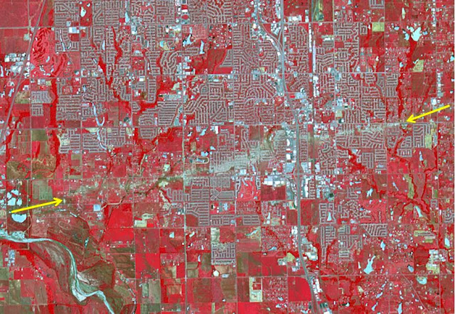
Path of the Newcastle-Moore, Oklahoma EF-5 Tornado


The Newcastle-Moore EF-5 tornado ripped through central Oklahoma on May 20, 2013, killing 24 people and leaving behind more than $2 billion in damage. On June 2, 2013, the Advanced Spaceborne Thermal Emission and Reflection Radiometer (ASTER) instrument on NASA's Terra spacecraft captured this image showing the scar left on the landscape by the tornado's deadly track. In this false-color image, vegetation is red, water is dark blue, roads and buildings are gray and white, and bare fields are tan. The tornado track crosses the image from left to right as indicated by the arrows. The image covers an area of 6 by 8.6 miles (9.6 by 13.8 kilometers), and is located at 35.3 degrees north latitude, 97.5 degrees west longitude.

Image credit: NASA/GSFC/METI/ERSDAC/JAROS, and U.S./Japan ASTER Science Team
Note: For more information, see NASA Spacecraft Sees Tornado's Destructive Swath.

Thursday, May 30, 2013

Northwestern Crete


This image shows northwestern Crete, the largest and most populous of the Greek islands. It is a compilation of three radar images from Japan’s ALOS satellite acquired on 28 August 2010, 13 October 2010 and the third band created by combining the other two. In the lower-right, the bright cluster of radar reflections on the northern coast is the city of Chania, the island’s second largest city after Heraklion (not pictured). At the center of the image is the Rodopou Peninsula. Off the coast of the other peninsula to the left there are two small islands: Imeri Gramvousa to the south and Agria Gramvousa due north.

This image is featured on the Earth from Space video program.

Image credit: JAXA, ESA

Saturday, May 4, 2013

Macquarie Island, Australia


Macquarie Island lies halfway between New Zealand and Antarctica, and is part of Tasmania. Accidentally discovered in 1810, the island was used by sealers and as a base for Antarctic expeditions. In 1933 the island was declared a wildlife sanctuary, and in 1997 listed as a World Heritage Site. Birdlife International identified Macquarie as an Important Bird Area because it supports 3.5 million breeding seabirds of 13 species, including 5 breeds of penguins. The image is located at 54.6 degrees south latitude, 159 degrees east longitude, covers an area of 10 by 36 km, and was acquired January 9, 2011.

Image credit: NASA/GSFC/METI/ERSDAC/JAROS, and U.S./Japan ASTER Science Team

Friday, May 3, 2013

Istanbul, Turkey


Istanbul and the surrounding area in northwestern Turkey are captured in this image acquired by Envisat’s MERIS instrument on 9 June 2011. To the north is the Black Sea, which connects to the Sea of Marmara (center) via the Bosphorus strait. The Dardanelles strait connects the Marmara to the Aegean Sea (lower left corner). Turkey's largest city, Istanbul, is near the center of the image at the Bosphorus strait. Istanbul straddles two continents (Europe and Asia), making it a true meeting place of the East and the West.

Turkey’s location makes it vulnerable to earthquakes, with the 1000 km-long North Anatolian fault just 15 km south of Istanbul. Because earthquakes can suddenly render current maps out of date, satellite images are useful for updating views of how the landscape has been affected as well as creating reference cartography for emergency operations. In addition, before and after satellite images of the area enable authoritative damage assessment as a basis for planning remedial action.

Photo credit: ESA

Wednesday, May 1, 2013

Namib Desert


Korea’s Kompsat-2 satellite captured this image over the sand seas of the Namib Desert on 7 January 2012. The blue and white area is the dry river bed of the Tsauchab. Black dots of vegetation are concentrated close to the river’s main route, while salt deposits appear bright white. Running through the river valley, a road connects Sossusvlei to the Sesriem settlement. At the road’s 45th kilometer, seen at the lower-central part of the image, a white path shoots off and ends at a circular parking area at the base of a dune. This is Dune 45, a popular tourist stop on the way to and from Sossusvlei. In this image, there appears to be some shadow on the western side. From this we can deduce that the image was acquired during the late morning.

ESA supports Kompsat as a Third Party Mission, meaning it uses its ground infrastructure and expertise to acquire, process and distribute data to users.

This image is featured on the Earth from Space video program.

Photo credit: KARI/ESA

Saturday, April 27, 2013

Lighthouse Atoll, Belize


The Lighthouse Atoll in the Belize Barrier Reef is featured in this image acquired on 29 March 2011 by Japan’s ALOS satellite. In the upper-central part of the image, an underwater sinkhole known as the Great Blue Hole appears as a dark blue circle. Surrounded by the shallow waters of the coral reef, the Great Blue Hole measures over 300 m in diameter and about 123 m deep. Formed when the sea level was much lower, rain and chemical weathering eroded the exposed terrain. Water later filled the hole and covered the area when the sea level rose at the end of the ice age.

Also visible in the image are two coral islands – green with vegetation – called cayes. The larger to the west is Long Caye, and the smaller Half Moon Caye is to the east.

This image is featured on the Earth from Space video program.

Photo credit: JAXA, ESA

Tuesday, April 23, 2013

Location of the April 20, 2013 Sichuan Earthquake


A powerful magnitude 6.6 earthquake struck Sichuan Province in southwest China on April 20, 2013, killing scores and injuring thousands, according to BBC News. Villages and roads near the epicenter were left in ruins, hampering rescue efforts. The earthquake occurred along the same fault that ruptured in 2008, killing tens of thousands and leaving some 5,000,000 people homeless. This perspective image from the Advanced Spaceborne Thermal Emission and Reflection Radiometer (ASTER) instrument on NASA's Terra spacecraft, acquired in 2003, highlights the epicenter of the new earthquake. Vegetation is displayed in red; clouds and snow are in white.

Photo credit: NASA/GSFC/METI/ERSDAC/JAROS, and U.S./Japan ASTER Science Team

Saturday, April 20, 2013

Democratic Republic of Congo


An area in the northwest of the Democratic Republic of Congo is pictured in this image taken on 26 June 2011 by the French SPOT-4 satellite. Most of the lighter green areas are deforested, while the darker green are areas of dense – and possibly natural – vegetation. The lines cutting through the image are roads, many with structures built along them. Clusters of purple dots are larger settlements. A river snakes through the upper part of the image and below it there appears to be a square in light green. Judging by the precision of the outline, we can deduce that this is a patch of land that was either intentionally spared from deforestation or has been reforested.

This image is featured on the Earth from Space video program.

Photo credit: CNES/Spot Image/ESA

Note: The ESA has recently started to provide their best photographs in TIF format only. I personally converted this image to JPG format so that I could share it on this blog.

Wednesday, April 17, 2013

The Brazil-Bolivia Border


The river-delineated border between western Brazil's Acre province (upper left), and northwestern Bolivia's Pando Department (lower right), demarcates a remarkable difference in land use and development practices. Brazil has opened up this part of the rain forest to farming and settlement, producing the herringbone pattern of forest cutting. This part of Bolivia, on the other hand, preserves its native rain forest, untouched by development. The image was acquired July 2, 2008, covers an area of 42 by 45 km, and is located at 10.3 degrees south latitude, 67.2 degrees west longitude.

Image credit: NASA/GSFC/METI/ERSDAC/JAROS, and U.S./Japan ASTER Science Team

Tuesday, April 16, 2013

PROBA Vegetation

Loading...


Soon to be launched aboard the second VEGA flight from Kourou, PROBA V, V for Vegetation, is part of a series of small satellites made by ESA to demonstrate new technologies on orbit.

But this satellite - of only one cubic meter - will be an operational tool to monitor vegetation on Earth.

This video explains the mission of this innovative satellite mostly made in Belgium.

Video credit: ESA

Thursday, April 11, 2013

Location of April 9 Iranian Earthquake


On April 9, 2013 at 11:52 GMT, a magnitude 6.3 earthquake hit southwestern Iran's Bushehr province near the town of Kaki. Preliminary information is that several villages have been destroyed and many people have died, as reported by BBC News. This perspective view of the region was acquired November 17, 2012, by the Advanced Spaceborne Thermal Emission and Reflection Radiometer (ASTER) instrument on NASA's Terra spacecraft. The location of the earthquake's epicenter is marked with a yellow star. Vegetation is displayed in red; the vertical exaggeration of the topography is 2X. The image is centered near 28.5 degrees north latitude, 51.6 degrees east longitude.

Photo credit: NASA/GSFC/METI/ERSDAC/JAROS, and U.S./Japan ASTER Science Team

Monday, April 8, 2013

Failaka Island


Kuwait's Failaka Island is located 50 km southeast of the spot where the Tigris and Euphrates Rivers empty into the Persian Gulf. For thousands of years the island has been a strategic prize to control the lucrative trade that passed up and down the Persian Gulf.

Photo credit: NASA/GSFC/METI/ERSDAC/JAROS, and U.S./Japan ASTER Science Team

Sunday, April 7, 2013

Severe Flooding in La Plata, Argentina


The Advanced Spaceborne Thermal Emission and Reflection Radiometer (ASTER) instrument on NASA's Terra spacecraft captured this view of severe flooding in La Plata, Argentina, on April 4, 2013. Torrential rains and record flash flooding has killed more than 50 and left thousands homeless, according to news reports. La Plata is located 20 miles (50 kilometers) from Buenos Aires. In the image, flooded areas east and west of the city appear in dark blue. A heavy sediment load gives the Rio Plata its yellow-brown color. The image covers an area of 15.8 by 16.7 miles (25.5 by 27 kilometers) and is located at 34.8 degrees south latitude, 58 degrees west longitude.

Photo credit: NASA/GSFC/METI/ERSDAC/JAROS, and U.S./Japan ASTER Science Team

Saturday, April 6, 2013

Galeras Volcano, Colombia


This false-color image of Colombia's Galeras Volcano, was acquired by UAVSAR on March 13, 2013. A highly active volcano, Galeras features a breached caldera and an active cone that produces numerous small to moderate explosive eruptions. It is located immediately west of the city of Pasto. UAVSAR will precisely fly the same flight path over the volcano in 2014. By comparing these camera-like images taken at different times, interferograms are generated that reveal changes in Earth's surface caused by volcanic deformation.

UAVSAR is part of NASA's ongoing effort to apply space-based technologies, ground-based techniques and complex computer models to advance our understanding of Earth deformation processes, such as those caused by earthquakes, volcanoes and landslides. UAVSAR is also serving as a flying test bed to evaluate the tools and technologies for future space-based radars, such as those planned for a NASA Synthetic Aperture Radar (SAR) mission currently in formulation. That mission will study hazards such as earthquakes, volcanoes and landslides, as well as global environmental change.

Image credit: NASA/JPL-Caltech

Friday, April 5, 2013

Napo River in Ecuador and Peru


On March 17, 2013, NASA’s Uninhabited Aerial Vehicle Synthetic Aperture Radar (UAVSAR) acquired synthetic aperture radar data over the Napo River in Ecuador and Peru. The image colors indicate the likelihood of inundation (flooding) beneath the forest canopy, which is difficult to determine using traditional optical sensors. Red and yellow shades indicate a high likelihood of standing water with emergent vegetation, blue and green shades are areas less likely to be inundated, and black indicates the open water areas of the Napo River. These data, which have already been transmitted to a field team working along the Napo River, will be used to guide field measurements during a second observation by UAVSAR on March 31, 2013. The image is a 8.7-mile-wide by 5.6-mile-long (14-kilometer-wide by 9-kilometer-long) segment of an image measuring more than 124 miles (200 kilometers) long. North is toward the upper right. The resolution is 20 feet (6 meters). UAVSAR data like these are helping scientists assess the effectiveness of using synthetic aperture radar data to study the inundation dynamics of this and similar rivers around the world.

Image credit: NASA/JPL-Caltech

Note: For more information, see NASA Flies Radar South on Wide-Ranging Expedition; also, PIA16942: NASA Sends Unmanned Aircraft To Study Volcanoes and Wetlands.

Thursday, April 4, 2013

Samarra, Iraq


Radarsat-2 entropy image and archaeological map over the octagonal city plan of part of ancient Samarra, located about 130 km north of Baghdad, Iraq. These results were found by Nicole Dore using the remote sensing technique Polarimetric SAR in a collaboration between Italy’s La Sapienza and France’s Rennes 1 universities.

Image credit: Satellite image: VigiSAT; Map: A. Northedge, 2007 The Historical Topography of Samarra. Samarra studies I.